
CMABS News: October 31, 2025
Hallow Halloween! 🎃 👻 Let’s dive into what is going on in the life of our city’s streets right now. ⤵️


The Safe Routes to School Survey is Still Live!
Here’s your reminder to take the survey and share it with friends and neighbors! The City wants to hear from residents about concerns and ideas for making streets around schools safer for kids. This is a great chance to make your voice heard.
Visit the project website to learn more and add your input. You’ll find both a short survey and an interactive map where you can mark locations, leave comments, and see what others have shared.
Regarding the 19th Street Bike Lanes
At the last City Council meeting, a Council Member asked staff to look into removing the westbound protected bike lane on West 19th Street between Pomona and Placentia, citing under-utilization.
We have a few thoughts on that.
First, the reduction from two westbound lanes to one (about 1,000 feet before the merge occurs anyway) and the addition of bollards are safety features—not just for cyclists, but for everyone on the street. According to data shared by Active Transportation Committee Chair Andrew Barnes in his April 2025 report to Council, there has been a reduction in the number of all car crashes in the area around the improvements (W. 19th St. and Placentia Ave), including those that involve pedestrians and bicyclists after the protected lanes were installed. The single vehicle lane and physical buffer from the sidewalk help drivers slow down and give people walking a much safer, more comfortable space.
Second, what happens on 19th Street affects people walking as much as it does people biking. The corridor is used daily by seniors, students, and families heading to schools, shops, and bus stops. Removing the protective barriers and adding another traffic lane directly against the sidewalk would narrow the pedestrian environment, increase noise and speed, and make everyday walking less pleasant and less safe.
We recognize that West 19th is a challenging street to design. Traffic volume drops quickly as you move west; it’s both a key thoroughfare and a walkable downtown corridor; and there’s never quite enough space for everything—cars, trees, and comfort. Still, safety should remain the top priority.
Bicycle Counts Database 👀

Costa Mesa has updated its Bicycle Counts Database, an interactive map that tracks how many people are walking and biking throughout the city.
The data offers a clearer picture of local travel behavior and helps inform future decisions about where to prioritize safer crossings, bikeways, and other improvements. It’s one more tool for understanding how Costa Mesans already move—and how better design can make those trips safer and more appealing.
Explore the map here!

Walk to School Day!
October is Pedestrian Safety Month, and as always, our schools have special Walk to School Days. Once again the Costa Mesa Police Department joined the kids for another successful year. Check out the video!

There’s a New Bike Bus in Town!
Parents at College Park Elementary School have organized a way to help kids get to school on their bikes in a way that’s comfortable for them and FUN! The College Park Bike Bus had its inaugural ride on Tuesday morning and will roll through the neighborhood every Tuesday morning throughout the school year. Be sure to follow them on Instagram and check out the coverage by the City. Go Cougars!

It’s Halloween!
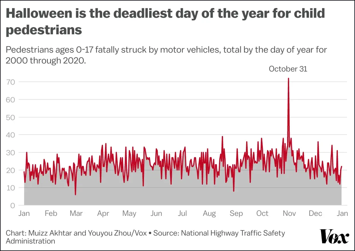
Halloween is a special time in part because neighbors are out and about walking the streets. It’s a favorite holiday of many urban designers, who see the tradition as a test of whether a neighborhood is working as a human-scaled environment that is amenable to accessing our homes on foot.
It is also unfortunately the worst day of the year for kids in terms of getting hit by cars. So those who will be driving in neighborhoods tomorrow afternoon and evening, we have some tips:
Drive under the speed limit (as we always should)
Turn off your radio
Roll your windows down
Keep your phone in your pocket


Join Lillördag — Costa Mesa’s weekly social bike ride!
When? Every Wednesday Night
@6:15pm meet up
@6:30pm ride begins
Where? Lions Park in Costa Mesa, meet by the restrooms on 18th street
What? Casual/Party pace bike ride, 10-15 mile rides around the area. 🚨Bring lights! 🚨
Follow them on Instagram for updates, pics, videos, and information on their monthly Saturday morning rides: https://www.instagram.com/lillordagbikeride/

Fairview Road and Safe Routes to School Workshop next Thursday! 🗓️
Speaking of College Park, improvements are underway for the southern portion of Fairview Rd. that will make it easier to walk and bike and safer to drive. From the City: The planned road work will involve new paving, bicycle and pedestrian improvements, transit improvements, and traffic signal upgrades. Additionally, a new pedestrian crossing will be provided south of Loyola Road to improve connections to College Park Elementary School.
Costa Mesa Safe Routes to School & Fairview Road Improvement Project Joint Community Workshop
🗓️ Thurs, Nov. 6 | 🕕 6–8 p.m.
📍Costa Mesa High School Library (2650 Fairview Rd)
Also learn about exciting improvements — including new bike lanes, safer crossings, and upgrades to Fairview Road — and share your ideas to help shape a safer future for every student. Light snacks and refreshments will be provided!
RSVP at bit.ly/47dLlZU
Visit the project website for the latest updates: www.costamesasrts.org
Fairview Park Master Plan
A new Fairview Park Master Plan was discussed at PACS last night and will be considered in the future by the City Council. Currently the plan prohibits bike use along most trails, including the bluff top trail on the west and cutting off access to the Canary Drive entrance to the east.
The draft plan also doesn't match the Circulation Element's proposed bikeways maps. Take a peek at the plan yourself, and look out for CMABS's full thoughts on socials soon!
That’s all for now. Have a great week!