
Low-Stress Bike Network - Recap
Analyzing Costa Mesa’s Bicycle Network and Starting to Imagine a Complete, Low-Stress, Bicycle Network in the City
By Marc Perkins

Here in Costa Mesa we have some incredible bike infrastructure: the Arlington Bioswale, Harbor Cornerstone Trail, and the Santa Ana River Trail, just to name a few. We’ve got great weather for bicycling, and mostly flat terrain. Yet when we look at the modes of transit that people choose to use, driving is by far the predominant choice in the city.
So, why don’t more people bike in Costa Mesa?
I commute by bike to my job at Orange Coast College, and when I talk to my colleagues about bicycling to work, one of the frequent reasons they give for not bicycling to work is that they live too far away. While distance can be a large impediment for bicycling, it’s likely not the reason that most people don’t bike.

Statistics from the 2009 National Household Travel Survey show that 50% of all trips are less than three miles, and 72% of those are driven, even though three miles is a perfect distance to bike. The 2017 update to the survey shows that the trends are the same, with 21% of all driving trips being under one mile, 46% of all driving trips being under 3 miles, and 59% of all driving trips being under 5 miles. So, while people may indeed be commuting long distances to work, most of the trips they take are within easy walking and biking distance.
The first reason people give for not bicycling and walking places is typically that it’s not safe. To analyze if our Costa Mesa bicycle network provides safe routes to destinations, I had to create a method to visualize our transportation network. I thus drew a subway-style map of the city. This map focuses on the primary network connectors of our city and streets that have bicycle facilities on them; residential streets are typically left off (both for clarity and because residential streets are not useful for most riders trying to travel reasonable distances, as neighborhood streets are frequently confusing to navigate).
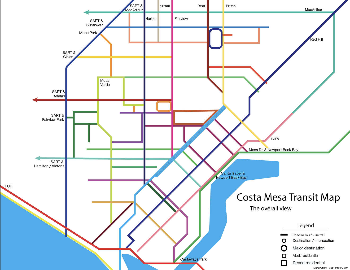
I next placed major destinations (circles) and dense residential areas (squares) onto the map:

Every pathway on that map is one that a person on a bicycle can legally use, so on the surface this network looks amazingly complete. However, many of these streets are horrifying to ride on. For example, this is what it looks like if you try to ride in the street on Adams at Harbor (a core intersection if you’re trying to get to Orange Coast College from the west):

This is not a part of our Costa Mesa transportation network I’d recommend riding a bicycle on.
So, we need to look at Costa Mesa’s transportation network with an eye to bicycle infrastructure. Here’s the transit map with our city’s bike infrastructure mapped onto it:

In this view dashed lines are bike lanes or sharrows, solid lines are off-street multi-use trails or protected bike lanes (of which we have none). This doesn't look too bad (many cities are far worse!), but we still have to map the destinations and residential areas onto this view.
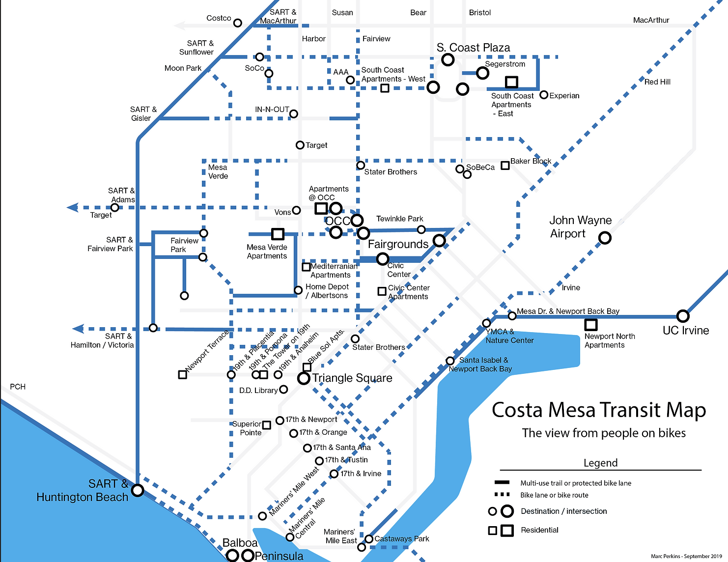
In this view, of bicycle infrastructure with destinations and dense residential areas, we're starting to see some destinations outside of the infrastructure (see, for example, 19th and 17th streets in the southern region of town). So, we’re starting to see gaps in the network: places where people who want safe places to ride bikes will be unwilling to travel.
But this view makes all of the bicycling infrastructure look safe and friendly for people, and this is far from the case. Here are two examples of what riding on some of those dashed lines looks like:

Adams west of Royal Palm: Drivers regularly travel more than 50mph next to a bike lane that is maybe five feet wide, including the gutter.

Fairview near Orange Coast College (just north of Adams): the bike lane disappears precisely when a bicyclist needs it most.
To reflect these differences in quality and safety of infrastructure, I categorized the bicycling infrastructure by stress level:

I divided the infrastructure into four stress levels, based on my personal experiences on the streets, their objective characteristics, and conversations with other local riders:
Green - low stress - a parent would be happy letting their kid ride well in front of them without worry.
Orange - moderate stress - parents with kids and new riders would likely be worried, and might well avoid the street; experienced street riders will be fine, but not relaxed
Red - high stress - parents with kids and new riders, if they try these at all, will avoid them unless forced onto them. Experienced riders will be anxious, and likely avoid them if possible
Maroon - crazy stress - the black diamond routes that only die-hard, or desperate, people on bikes take
If we want the average person (the "interested but concerned" 60% of folks) to consider bicycling as a means of transportation, then we need to look at the infrastructure through their eyes. And, what are these “interested but concerned” people, like my co-workers, looking for? Safe routes that they can relax on while riding (without worrying about being hit by drivers piloting vehicles badly).
So, let's display our city’s bike network as it looks to a rider who wants to ride on low-stress routes:

That's the state of our current bike network as it looks to the average person. I’d argue that this map illustrates why why people don't bike nearly as much as they could in Costa Mesa: there are essentially no low-stress routes that allow them to get where they want to go on a bicycle.
If we want people to replace driving trips with car trips, we need to build a comprehensive, low-stress bike network; infrastructure where scenes like this can happen organically:

That was it for my presentation. At this point broke out from a talk into small groups that pondered how to make our network better. We divided into groups that discussed both solutions involving both temporary infrastructure ("Summer lanes!") and permanent infrastructure ("What do we want to build in the next 10 years?")
Summer Lanes: Bike to the OC Fair!
People loved the idea of creating a “Summer bike to the OC Fair” day or week. For routes, we drafted out the following temporary ones:

Attendees proposed three routes into the fair that we'd create with signage and tactical urbanism techniques:
Coming from the southern eastside up Orange and then over on Santa Isabel, possibly with a dual-direction temporary protected bike lane on Vanguard Way (either in the middle of or on the east side side with the parking moved out further into the street)
Coming from Newport Back Bay down Mesa Drive
Coming from the north-west through Mesa Verde traveling down Country Club to Mesa Verde East to the Tanager Bike Path and Merrimac Way.
A fourth route, from the north, was considered (crossing the 405/73 along Bear, and then working through Mesa Del Mar), but provisionally rejected due to the lack of ability to safely support people at the 73 undercrossing.
What areas could we permanently improve to work towards a complete, low-stress network in 10 years?

This group focused on permanent infrastructure solutions to help solve our lack of network connectivity, both looking at what is included in our active transportation plan and independently thinking about what we could do to create a cohesive network. Discussions here focused on one idea that seemed most practical: creating an east-west connection in the middle of the city by
Using signage and street markings to assist riders through the Upper Birds neighborhood (between Fairview Park and Mesa Verde East / the Tanager Trail)
Building a protected bike lane on Merrimac Way (which is currently being designed by the city)
Building an off-street multi-use trail along the west side of the OC Fairgrounds and improving the existing off-street multi-use trail along the south side of the OC Fairgrounds
Creating a safe route along Vanguard Way and Santa Isabel
Constructing the Paularino Channel Trail, both the currently proposed version (from Fairview to Bristol) along with its extension (from Fairview to Pinecreek Drive), to allow an easy connection from Orange Coast College (which connects to Merrimac / Tanager / Harbor Cornerstone / Joann Street Trail) all the way to Bristol.
In addition to the above:
Creating a linked, safe bicycling route along 19th, Newport Blvd, and 17th Street (what we started calling the “Z scheme”) would dramatically improve bicycling in southern Costa Mesa, and almost certainly help local businesses flourish.
Linking the east-west path described above to northern Costa Mesa through two separate routes: the Mesa Verde route discussed in the Bike to the Fair portion as well as College Avenue / Gisler Ave to promote connections in the northern area of the city.
The Adams Improvement Project, connecting SART to Harbor along Adams via a protected bike lane.
Creating a safe, low-stress extension of Victoria’s off-street multi-use trail so that it reaches the Santa Ana River Trail in a low-stress manner
Conclusion
This meeting was just the start of our discussion; if you have ideas or want to help work together to make city’s streets better for all people, please e-mail us at info@cmabs.org or e-mail me personally at marc@cmabs.org. And if you want to keep getting our updates, sign up for our e-mail list here.
Also, if you have ideas on how to improve this visualization, such as other items to map onto it or other mechanisms of categorizing our infrastructure, please contact me - the map is easy to edit.